

Ground Investigation and Stability
A practical introduction to investigating ground conditions, choosing and verifying ground improvement, assessing and stabilizing slopes, and managing geotechnical uncertainty.
From Site Evidence to a
Start with the project question
A site investigation is not simply a program for collecting samples. It is planned to reduce uncertainty about ground conditions that matter to a proposed structure—for example, bearing capacity, settlement, slope movement, , or construction difficulty. The investigation should answer a design question, and its methods should fit the expected ground and the information needed.
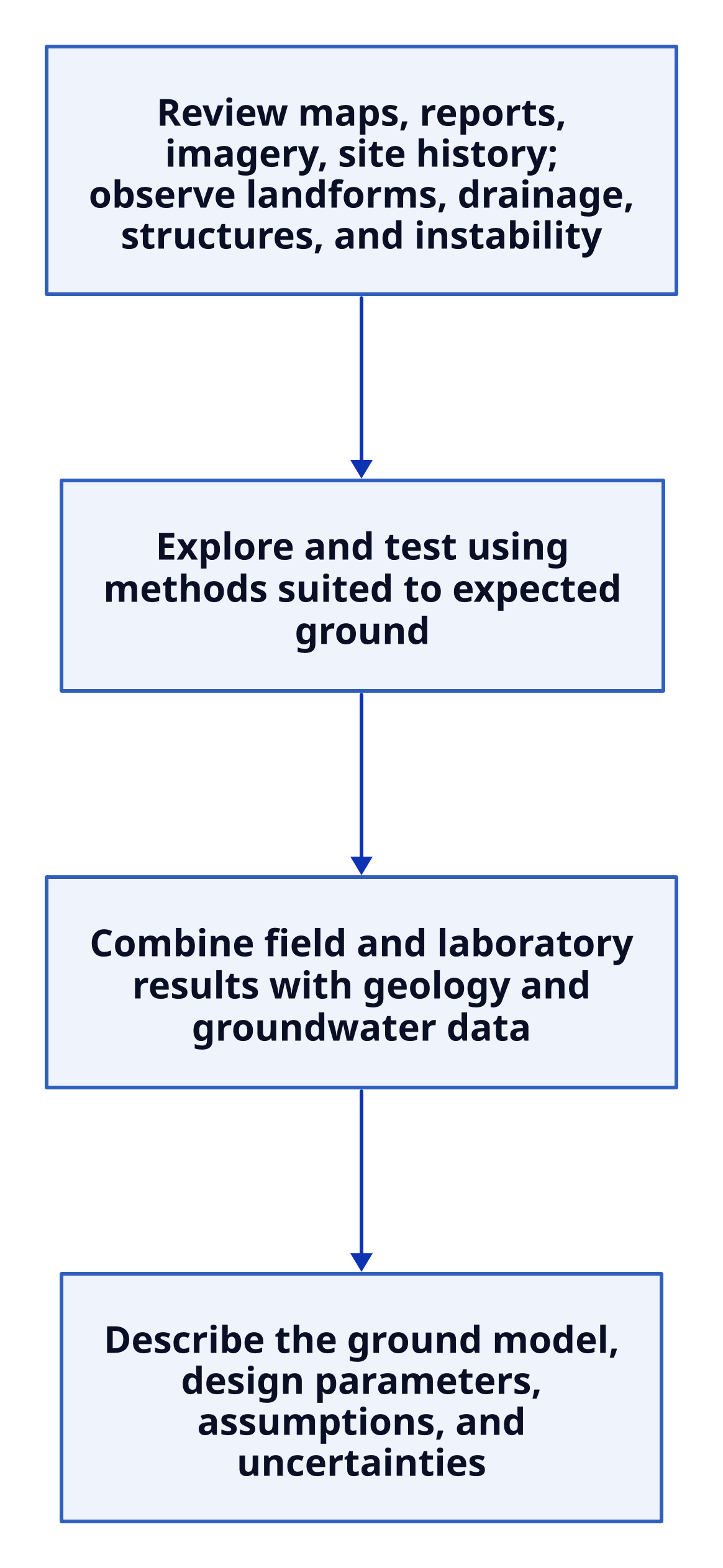
The work typically moves from background review and site observations to exploration and testing, then to interpretation and reporting. These stages build on one another: background information helps identify what to look for; exploration and tests provide evidence; and interpretation combines that evidence into a model engineers can use.
Text description
From investigation to ground model Four process boxes arranged from top to bottom: review background and observe the site; explore and test the ground; interpret field, laboratory, geology, and groundwater evidence; report a ground model with assumptions and uncertainties. Layout: down. Review maps, reports, imagery, site history; observe landforms, drainage, structures, and instability Explore and test using methods suited to expected ground Combine field and laboratory results with geology and groundwater data Describe the ground model, design parameters, assumptions, and uncertainties Review maps, reports, imagery, site history; observe landforms, drainage, structures, and instability → Explore and test using methods suited to expected ground Explore and test using methods suited to expected ground → Combine field and laboratory results with geology and groundwater data Combine field and laboratory results with geology and groundwater data → Describe the ground model, design parameters, assumptions, and uncertainties
Choose evidence that answers the question
Desk study and reconnaissance review geological and topographic maps, aerial imagery, previous reports, and site history. A site visit adds direct observations of landforms, drainage, exposed ground, existing structures, and signs of instability.
Exploration methods provide different kinds of evidence. Borings provide samples and subsurface observations; test pits expose shallow soils; and SPT or CPT measurements help characterize soil layers. Geophysical methods can help trace changes between exploration points, but generally need interpretation alongside direct investigation. Laboratory tests—selected for the design question—may measure particle-size distribution, plasticity, density, water content, compressibility, or shear strength. Testing every property indiscriminately is not the goal.
Interpret observations with care
The combines field observations, test results, geology, and data. A report should distinguish observed facts from interpretation and clearly state assumptions, uncertainties, and parameters relevant to design. Ground conditions can vary, so the model is an informed representation, not a claim that every point on the site is identical.
For example, for a road embankment over soft clay, borings and in-situ tests can establish the clay’s thickness. Samples and laboratory tests can help estimate compressibility and strength. Those findings then inform whether direct construction, staged construction, or should be considered. needs particular attention: a level recorded during drilling is only a snapshot. If affects stability, excavation, or settlement, monitoring over time may be needed to understand its behavior.
Choosing and Verifying
Define the limitation before choosing a method
should respond to a specific problem and a project performance target. The limitation might be low strength or density, excessive settlement, slow , , or poor stability. Method selection then depends on soil type, depth and extent of weak ground, , nearby structures, access, schedule, and cost. There is no single treatment that suits every ground condition.
The comparison below is a starting point for matching methods to their stated purposes, not a substitute for site-specific design.
| Approach | Ground or purpose | How it helps |
|---|---|---|
| Compaction, vibrocompaction, dynamic compaction | Suitable loose granular soils | Increase density |
| Preloading with vertical drains | Compressible soil; speed consolidation | Temporary surcharge increases stress; drains shorten the water-escape path |
| Soil replacement or lightweight fill | Shallow unsuitable material or embankment loading | Remove unsuitable soil or reduce the load and potential settlement |
| Stone columns or deep mixing | Weak ground at depth | Reinforce, partly replace, or mix ground with a binder |
| Grouting | Depending on grout and soil conditions | Fill voids, strengthen ground, or reduce seepage |
Specify a target and verify the response
A treatment choice needs to be translated into a design that states the target performance and includes construction specifications and verification. The method must work in the actual ground and be carried out as designed; this is especially important for methods whose effectiveness depends on ground conditions and construction details, such as stone columns and deep mixing.
Consider the source example of soft clay treated with preloading and vertical drains. The surcharge applies temporary loading, while drains shorten the path for water to escape and can accelerate . Settlement observations can show whether is proceeding as expected before permanent works proceed. Where treatment performance depends on it, should also be monitored. These observations help verify whether the ground is responding as anticipated; they do not remove the need for appropriate design or construction control.
Assessing and Stabilizing Slopes
Assess both resistance and the conditions acting on the slope
A slope is stable when the soil or rock’s are sufficient relative to the forces tending to move it downslope. Engineers assess this balance for potential failure surfaces using measured or justified strength and conditions. It is not enough to consider slope steepness alone: geometry, material strength, and seepage, loads near the crest, and changes such as excavation or erosion all matter.
Water illustrates how conditions can interact. Rainfall can raise and reduce , lowering available shear resistance. Added loading near the crest can increase the challenge to stability; removing support at the toe can also reduce it. These are reasons to use relevant ground and conditions in the assessment rather than treating a slope’s condition as fixed.
Interpret the appropriately
For a specified analysis, the expresses the ratio of resisting to driving effects:
The ratio summarizes that analysis; it is not a guarantee that a slope cannot fail. The method of analysis and the criteria used to judge a result depend on the project, loading case, , and applicable design requirements. A should therefore be understood in the context of the conditions and assumptions used to calculate it.
Match stabilization to the cause
Stabilization measures should address the identified cause of instability. Options include flattening the slope, improving drainage, removing material near the crest, adding support near the toe, or using reinforcement such as soil nails. These options address different aspects of slope conditions, so choosing among them requires understanding what is contributing to instability.
Landslides commonly occur on steep or weak ground and may be triggered or worsened by water and other changes to slope conditions. Monitoring movement and can help determine whether the slope is responding as anticipated. Monitoring complements assessment and stabilization: it provides information about actual behavior, rather than assuming the response from the design alone.
Managing Geotechnical Risk
Organize the assessment around hazard, , and consequence
Geotechnical risk arises when uncertain ground conditions interact with design or construction in ways that could cause harm, delay, or added cost. A useful assessment separates three questions:
Hazard: What ground condition could cause a problem—for example, soft soil, a high water table, or a potentially unstable slope?
: Which people, structures, or work could be affected?
Consequence: What could happen if the hazard affects that ?
Keeping these questions distinct helps make the risk description more useful than simply naming a difficult ground condition.
Manage risk throughout the project
Risk management starts during planning and continues through construction. Investigation reduces uncertainty; design and construction measures reduce the likelihood or consequences of problems; and monitoring can warn when conditions differ from expectations. A geotechnical report should identify important uncertainties and distinguish observed facts from interpretation, so decisions can be understood in light of the evidence and assumptions.
If unexpected materials, , or movement appear during construction, the response should not be to assume the original investigation settled the matter. Review the and, when needed, change the work. Investigation cannot eliminate all uncertainty; the practical goal is to manage the and respond when actual ground behavior differs from expectations.
: A measurement made in the ground, rather than on a sample tested in a laboratory, to help characterize soil layers.
: A potentially harmful ground condition, such as soft soil, a high water table, or an unstable slope.